|
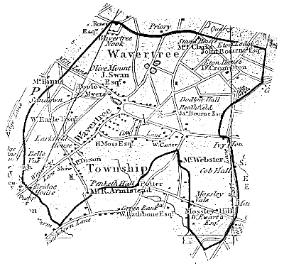
Until it was absorbed by the City of Liverpool in 1895, Wavertree was a township within the County of Lancashire. Its boundaries were clearly marked on Ordnance Survey and other official maps, but they did not always follow obvious features - whether natural or man-made - on the ground. At certain key points, markers made of either cast iron or stone, and labelled 'B.P.' (Boundary Post) or 'B.S.' on the map, were installed to confirm the identity of the adjoining townships. Some of these have survived to the present day, even though for practical purposes the old boundaries are no longer relevant.
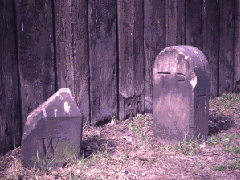
Few people today are aware that a portion of Victoria Road in Aigburth was once part of the Township of Wavertree. The boundary between Wavertree and Toxteth Park ran along Penny Lane, and then followed a zig-zag course to the north of Smithdown Road and along part of Garmoyle Road. The only surviving indication on the ground is the 'T.P.' stone (upper picture) in North Mossley Hill Road, which has apparently lost its 'W.' counterpart. At one time there were, according to the maps, several boundary stones off Smithdown Road (e.g. behind the Brook House pub, which was in Toxteth Park). Two of these (lower picture) survived into the 1960s within Wavertree Playground.
The original population of Toxteth Park was evicted when King John turned the area into a Royal hunting forest. Domesday Book, 100 years earlier, had listed 'Esmedune' (Smithdown) along with 'Wauretreu' (Wavertree). It seems reasonable to assume that, when the Toxteth deer park was created, the remaining part of Esmedune was incorporated in Wavertree township. This would account for the 'tongue' of Wavertree extending southwards from Allerton Road, between Rose Lane and Penny Lane (see map below). The usual name for this area is Mossley Hill - i.e. the 'smooth down' that gave rise to the names Esmedune and Smithdown?
|
|


