|
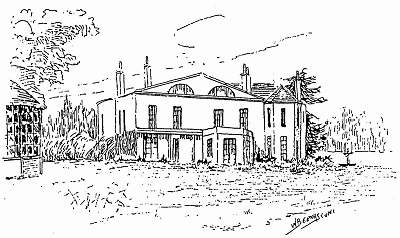
'The Grange' was the name of a house which stood on the west side of Cow Lane - renamed Prince Alfred Road in 1866 - opposite the end of Hunters Lane. It had the benefit of extensive views across the countryside towards the growing port and town of Liverpool, three miles away, and would have appealed to business/professional men who, in the early 19th century, wanted to live on a 'country estate' within an easy carriage-ride of their place of work.
Bennison's map of the Environs of Liverpool (1836) indicates the owner of Wavertree Grange as Henry Lawrence. This is confirmed by Leather's map (also 1836) which is the earliest surviving large-scale map of the Township of Wavertree. Henry Lawrence was a barrister, listed on the 1841 and 1851 Censuses as unmarried, living in Rodney Street, Liverpool with three servants. In 1832 he had advertised Wavertree Grange 'To Let', describing it as "late the residence of Henry Moss Esq".
Henry Lawrence also had property interests in Jamaica; as did his brother Charles Lawrence (of Wavertree Hall and, later, Mossley Hill). A family tree entitled Lawrence of Jamaica includes "Henry Lawrence of Wavertree Grange ... formerly of Jamaica, born 1779 in Somerset Street [London], died 1864". It is unclear, though, how much of his time he spent in Wavertree. In 1853 he wrote to the Wavertree Local Board of Health, offering £250 towards the cost of a 'sewer link with the Liverpool outfall', but his letter came from "Holly Bush, Burton on Trent". This was the home of a relative, Thomas Kirkpatrick Hall. It is worthy of note that Henry Moss (a Liverpool banker who owned slaves in British Guiana), Henry Lawrence, Charles Lawrence and Thomas Kirkpatrick Hall are all listed as having been compensated by the government in 1835-8 following the abolition of slavery.
In 1848 Henry Lawrence once again advertised Wavertree Grange 'To Let'. This time it was "late in the occupation of Henry Killick Esq". The Wavertree Tithe Map of 1845-6 had identified the Grange estate (i.e. Plots 816-824) as 19 acres in extent, owned by Henry Lawrence and occupied by Henry Kellick (sic). It comprised a "House, Outbuildings, Gardens & Pleasure Grounds", a Fish Pond, five Fields and two wooded "Plantations". Henry Killick was a Liverpool merchant with an office in York Buildings, Sweeting Street.
|
|

