|
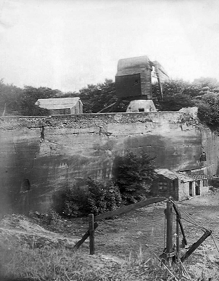
A question frequently asked, on Heritage Open Day and at other events, is "where did the sandstone come from to build the Lock-up?". The answer, almost certainly, was the Township Quarry in Woolton Road, on the site of present-day Mendip Road. The Wavertree Enclosure Act of 1768 made special provision for protecting the flow of wind to Wavertree Mill, which stood on high ground close to what is now the junction of Beverley Road and Charles Berrington Road. Alongside it, to the east, the Enclosure Map includes the words 'Left for Stone'; it was this area that became the township quarry. According to the local historian James Hoult (writing in 1913) this was a 'free quarry' from which the householders of Wavertree had the right to help themselves to stone. He says that by 1837 it had become dangerous, so it was railed off and converted into a pound for stray animals. Nevertheless, on the Wavertree Tithe Map of 1845 it is still described as a 'delf' (a local name for a quarry) owned by the Township of Wavertree.
The photograph reproduced here has been posted on Facebook several times over the past 15 months - always with the caption "Woolton Quarry 1896". Woolton village, just 3 miles south-east of Wavertree, was of course well known for its sandstone quarries; and in 1883 Sir James Picton specified 'white Woolton stone' for his Clock Tower. But in fact the quarry in this picture was in Wavertree - just west of the Mill, where Tor View Road is today. The Tithe Map indicates this second 'delf' as the property of Robert Crowther. The 1851 Census describes him as a Stone Dealer (in 1841 he had been a Stone Mason) born in Heptonstall, Yorkshire, but living in Hadfield Place, Much Woolton.
|
|


